

GRAND CANYON, AZ — Rim to Rim (R2R).
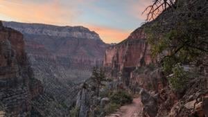
This canyon has it all! Views for days, waterfalls, cacti, towering mountain faces, massive rivers, the biggest ravine or gorge you’ve ever seen. Some might even call it Grand. I work with words and I am having a difficult time finding the synonyms to describe its beauty and complete grandeur. If you need to get out and ground yourself for a day, this is definitely the place to do it.
If you are looking for an unforgettable view of a sunset overlooking one of the most stunning geological masterpieces within a day’s drive — look no further. You can take a shuttle around the rim of the Grand Canyon or ride a mule, or you can hike it. I hiked it. Here is my review and recap of the North Kaibab and Bright Angel trails.
FAST FACTS:
Trailhead Location: North Kaibab Trailhead is in Fredonia, AZ at the North Rim of the Grand Canyon.
Distance:
24 miles (one way) according to the National Park Service. Plan on anywhere between 24-26 miles.
Difficulty Level: Intermediate to Advanced. People of all ages, including children to the elderly can hike it, but need to prepare. This is not a spontaneous hike. Make sure your heart and other medical conditions are stable before committing to this hike. I recommend going with a group of other experienced hikers or a guide.
Elevation Gain:
6,000 feet change in elevation. Begin at North Kaibab Trailhead 8,200’ down to 2,400’ at Phantom Ranch and back up to 6,800’ at the Bright Angel Trailhead.
My experience hiking R2R:
If you want to vicariously live hiking R2R through me or know what to prepare for, read on.
R2R. What a silly idea to hike from one edge of the Grand Canyon to the other in a day – but I did it.
I hiked more than a marathon with a backcountry pack. And I saw other people out there doing the same thing all while wearing smiles on their faces. It was wild!
Some say it was 26 miles long, the National Park Service’s website says it is a 24-mile journey. My GPS said I hiked 30 miles. AND. I. BELIEVE. IT.
A year ago, I recall seeing Instagram videos of people riding pack mules in the Grand Canyon stating “this is the only way to explore the Grand Canyon.” I remember thinking, “that looks insane/miserable. Why would anyone do that to themselves, even on a mule?” Well, I did it recently – without a pack mule and it was memorable and worthwhile. I’ll tell you why.
How It Happened:
I was invited to hike Rim to Rim of the Grand Canyon in the early Spring with a group of about a dozen people. My immediate answer was an impulsive “yes,” but I quickly realized I needed to follow it up with consistent conditioning, training over the next six months. So I put in the work, hit the gym, went on a lot of hikes and was rewarded with still being able to walk pretty well and not limp after each subsequent recovery day!
I learned a few things from the whole experience:
If you are planning on embarking on a hike that covers 26+ miles of rugged mountain terrain, 5,000 feet in elevation change, 95-100° F+ degree temperature – you should bring a few things with you.
Let me first give the disclaimer, I am not a doctor and none of this is medical advice. This is just what I learned preparing for the hike, working with a nutritionist, and talking to a Grand Canyon National Park medic on the trail about what he has learned in his more than decade of experience rescuing people from the bottom of the canyon.
Things to bring with you or do different than a typical hike:
- Pack 2-3 Liters of water
- Have electrolyte powder drink mix or tablets
- Have snacks (including candy) and food high in sodium and carbs to consume several of every hour of your hike. (This not only helps expedite recovery afterwards, but maintains your energy as you go).
- Eat along the trail as you hike
- Hiking poles
- Battery pack to charge your phone, it will die otherwise, especially if you are using GPS to track your hike.
We began hiking with headlamps at 8000’ on the North Rim at the North Kaibab Trailhead at the around 4 a.m., before the sun even grasped the concept of rising. We descended into the Grand Canyon, knowing we had to drop all the way down to about 2,200’ at the bottom of the canyon before hiking back up to the South Rim at Bright Angel Trail.
It was unforgettable watching a trail of headlamps from hikers zigzagging down into darkness. Then slowly, as dawn became a reality, a silhouette of the horizon began to show as the sky illuminated behind it. Then the Grand Canyon’s character, jagged cliffs and rocky terrain began to show up. But at this time the headlamps were still necessary. Now you could see the world-renown scenic topography coupled with glowing of hikers’ headlamps bumbling along the trail, like inchworms along a tree branch.
The most comfortable time hiking was in the twilight. As the sun slowly started to crawl its way over the rim and into the deepest parts of the canyon, I began to treasure the shady spots or areas where the sun had yet to touch. I knew once the sun was upon us, it would be a completely different, hotter, more exhausting hiking experience … and it was.
There were beautiful waterfalls dropping over big boulders. The desert landscape and majestic towering cliffs grew bigger as we hiked lower into the canyon. During the early part of the hike, you could occasionally see metal poles (constructed in the early 1900s) with wires still connected to them. I learned these unique-looking poles were remnants of the Trans-Canyon Telephone line, that used to be a telephone line system that went from the North to South rim of the canyon.
By the time we arrived at Phantom Ranch, the lowest part of the trail before crossing the Colorado River, the sun was intense. The temperature was about 10 degrees warmer than typical for mid-October. So even though October is a great time to hike the Grand Canyon, it was still unseasonably hot and in the upper 90s. This was a time to stop and dip your feet in the nearby Bright Angel Creek. And if you are into sending someone the most unique piece of mail they’ve ever received, you can buy a postcard that is stamped, “Mailed by mule from the bottom of the Grand Canyon.” Daily they have a pack mule take a satchel of mail up to the top. You can also fill up your bottles and water bladders at the water stations. There is a small lodge at the bottom, The Phantom Ranch Canteen, where you can buy snacks, lemonade, or even have a sit-down breakfast or dinner if you made prior reservations. All of these convenient options come at a premium price, though. You definitely pay for the convenience.
If at any point you think what you are doing is insane, there is always someone on the trail hiking past you with a full-sized bicycle strapped to their back or trail running the whole thing to provide you perspective and let you know, you’re still NOT that intense. The hike from rim to rim typically takes between 10-12 hours, but it’s wild to see people running past you that started on the south rim, made it to the bottom and are heading up the north side – all before you’ve even had lunch. Ha ha. I saw children on the trail and even heard of a 94-year-old who all completed the hike that day.
Once you cross the Colorado River, you definitely want to take some time to enjoy that view and experience crossing that massive bridge. If you are lucky, you will see some white water rafts passing by and hitting some rapids as you cross the bridge overhead, like we did.
After you cross the Colorado River, shade is very hard to come by and the sun is getting its afternoon burn on. At this point, you are also hiking upward by switchbacks and approaching an area nicknamed the Corkscrew. Previously, the hike wasn’t too bad if you had OK knees and used hiking poles to descend town the trail – but now you’re hiking up, and your quads are going to feel it. You will relish any time you head around a bend and a wall of rocks or hillside shades you temporarily from the intense heat.
There are about three more water stations on the way up to the south rim. If you didn’t think you needed much water before or could skip a water fill up, think twice this time. You’ll need all the water, electrolytes, sodium and snacks you can stomach to help replenish what you lose by sweating it out along the hottest part of the trail.
About 9 miles from the top, I am wearing a towel over my head and dunking it, and my head, at every possible creek At this point in the trail I passed an informational sign that showed an artistic rendering of a half-dressed man on his hands and knees violently vomiting with the following comforting message, “Hiking to the Colorado River and back in one day is not recommended due to long distance, extreme heat, and a nearly 5,000 foot elevation change. If you think you have the fitness and expertise to attempt this extremely strenuous hike, please seek advice from a park ranger at the Backcountry Information Center.”
NOW they tell me! I just had to laugh at this point and figure this same warning sign was on the north rim as I hiked down and it was pitch black in the morning so I didn’t see the warning at that time.
As I reached Havasupai Gardens, an analog thermometer hung on a wooden sign reading 120° F. I joked with the park ranger, sitting in the shade checking on hikers, that there was no way that thermometer reading was accurate and must be there as a static novelty item. He surprised me when he suggested, with the direct sunlight and not just an ambient temperature reading, it might be pretty close to real feel. He said in the summer, a temperature reading off the asphalt with an infrared temperature gun has exceeded well over 120 degrees. So, needless to say, if you want to lay on the ground at any point, pick the dirt and not any good conductor of heat. In fact, according to the National Park Service’s website, temperatures at the bottom of the Grand Canyon “hit 120°F at Phantom Ranch on several dates during summer months.”
As I refueled by eating some sliced pickles, something I never thought would be so amazing and refreshing along the trail, I learned a few things from that park ranger in his 12 years of experience as a medic rescuing people.
Namely, not all commercial electrolytes are created the same, so as a backstop, put a pitch of table salt in every liter of your water to ensure you get enough sodium replenishment. In his experience, he suggested people were easier to revive if they were dehydrated than over-hydrated (or experiencing hyponatremia, where there is a sodium imbalance). He explained with dehydration, they can put in an IV and quickly revive a patient with prompt delivery of proper nutrients to the cells. With over-hydration the electrolytes are essentially flushed out of the cells with too much water, so it takes a bit longer to replenish that imbalance, but it is possible. The tricky part is symptoms of dehydration vs. over-hydration may look and feel similar. This is where the best advice is to seek a nearby park ranger and hike with a buddy or group of people who can help recognize those symptoms.
After Havasupai Gardens, there are 4.5 miles left. Depending on the time of year you are there and how quick or slow you are hiking, the sun might start setting and a welcome breeze will come in. Which is great and you might feel a 2nd, 3rd, or 24th wind and a final push of “let’s just get this over with” energy, but you also might feel the worst cognitive dissonance of your life as you hike what seems to be the longest 4.5 miles of your life.
Next, there is a Three-Mile Resthouse, and a Mile-and-a-Half Resthouse, which were appropriately named for the distance left in the hike. Although, I will suggest someone’s measuring equipment should be re-calibrated or simply carve into the trail signage to simply say – “longer than you think.”
That last mile felt like a LOT more than 5,280 steps.
But it’s all worth it when you experience the accomplished feeling and desire to howl with the coyotes at the top of a hollow canyon, which is so big it can be seen from space. There is nothing like the feeling you get when you reach the Bright Angel Trailhead on the top of the South Rim.
Recovering after the hike is the final step of the experience. If it feels terrible for days, you may never want to do it again. Until you get amnesia or it’s been long enough for you to forget how bad your legs felt. I used moleskin and wrapped some hot spots, so I didn’t have any horrible blisters or foot pain. At 40 years old, I had no shame in stopping briefly along the trail to stretch and move that lactic acid around for the muscle groups that weren’t being used the same way as I hiked up as they were on the hike down. I feel that helped my overall muscle recovery and mobility along the trail.
I felt good during most of the hike in my muscles and joints. I had prepared and gone on hikes for about 6 months and had been exercising regularly at the gym and staying active, which I don’t doubt helped. I was a bit sore in my quads and calves the day after, but not hating life. The following days got better, instead of worse with each day, (which typically is the scenario for me and my Elder Millennial body nowadays).
The game-changer for me was learning how proper and steady nutrition along the trail can make all the difference! I was fortunate enough to go with a group that had a nutritionist leading it. We were told what types of snacks to eat and how often to snack along the trail to make sure we weren’t playing catch up. Without this help I would have brought only water and granola bars. I learned once you are on the trail playing catch up on nutrition it is too late and your body lets you know it! In the past, on most shorter hikes, I would hike until I was tired and then stop to eat or drink. I won’t do that going forward, because I have learned how helpful it is to consistently hydrate and replenish as you go. Regardless of the distance – you will feel better during AND after the hike.
Hiking Rim to Rim of the Grand Canyon taught me I can do things I never thought my body would be capable of, or actually enjoy! It was possible with goals, consistent habits and lifestyle changes. I also met a lot of like-minded people who understand maintaining some level of mobility as you age is a part of enjoying all of your life, and not just the first-half. I enjoy making memories and sharing experiences.
Solo-hiking is fine, and I do it plenty and let others know where I am going and hike prepared, but I believe experiences are always more enriched when you can share them with others. I met some people along the way who decided Rim to Rim wasn’t enough and were doing Rim to Rim to Rim (R2R2R) a nearly 50-mile trek with an 11,000 foot change in elevation. I also saw people training for the Arizona Trail (from Mexico to Utah). I would say all those ideas are insane, but I used to say that same thing about people who hiked R2R.
Ultimately, I learned and proved to myself how to do another hard thing and made a dozen new friends who all shared a life-changing experience … and if it didn’t change someone’s life — they weren’t listening.
Feedback welcome: If you have a hike you’d like me to review or recommendation to share with readers please email me at: cimaron@cvdaily.com
See other hike reviews:
Fall Hike Review: Highline Trail above Logan Canyon
Fall Hike Review: High Creek Lake
Fall Hike Review: Wind Caves in Logan Canyon
Hike Review: Hyde Park Canyon segment of Bonneville Shoreline Trail