
LOGAN, Utah — After a disappointing winter across much of the West, skiers in Utah have some reason to be optimistic about the upcoming season.
A new 2026-27 winter forecast from OpenSnow favors above-normal snowfall across Utah, including the mountains of Northern Utah. Idaho’s outlook is more of a mixed bag, with southern parts of the state generally looking better than areas farther north.
OpenSnow meteorologist Alan Smith said a strong El Niño developing in the Pacific Ocean is a major reason behind the forecast. It could eventually become one of the strongest El Niño events on record.
For Utah, Smith said past strong El Niño winters provide encouraging signs.
“While Utah is often in the awkward in-between zone when comparing El Nino vs. La Nina snowfall, during strong to super El Nino events, there is a stronger signal that favors above-average snowfall across Northern Utah, and for the state as a whole,” Smith wrote.
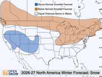
2026-27 snow forecast
That includes many of the ski areas along the Wasatch. OpenSnow favors above-average snowfall at Alta, Snowbird, Brighton, Solitude and Snowbasin, while Park City has shown an especially strong history of above-normal snowfall during the strongest El Niño winters.
The timing could also be important.
There isn’t a strong indication yet of whether November and December will be particularly snowy in Utah. The better odds arrive after the holidays, with January through March favored for above-normal snowfall.
While Northern Utah could get more snow, it may not necessarily be colder.
OpenSnow is also forecasting above-normal temperatures for Northern Utah. Smith said that could result in some storms bringing higher snow levels, meaning rain at lower elevations while snow continues to fall in the mountains.
Salt Lake City, for example, has historically received below-average snowfall during strong El Niño winters even as the mountains above the city have received above-average snow.
The outlook changes as you travel north into Idaho.
OpenSnow favors above-normal snowfall in southwestern Idaho, while much of the state has no strong indication one way or the other. The Idaho Panhandle is favored for below-normal snowfall.
Bogus Basin and Sun Valley could benefit from storms moving north out of California, although Smith noted that hasn’t happened consistently during every strong El Niño winter.
Brundage and Tamarack fall in the middle, with no clear indication of above- or below-normal snowfall.
The outlook is less promising for ski areas in northern Idaho, including Schweitzer and Silver Mountain, which have generally received less snow during strong El Niño winters.
Southern Idaho could see its best chances for above-average snowfall in January and March. Northern Idaho has a below-average snowfall signal throughout the winter, although Smith emphasized that doesn’t rule out periods of heavy snow.
The Utah and Idaho forecast is part of a much larger OpenSnow winter outlook covering ski regions across North America, Europe and Japan.
Smith based the forecast in large part on what happened during previous strong El Niño winters, particularly 1982-83, 1997-98, 2015-16 and 2023-24.
The developing El Niño is expected to continue strengthening into the fall and winter. Smith said it could potentially reach record levels.
Still, Smith cautioned against treating a seasonal outlook as a guarantee.
“As a reminder, winter outlooks contain an inherent degree of uncertainty since so many factors in the atmosphere are not predictable months or even weeks in advance,” he wrote.
For Utah skiers, however, the early outlook provides something last winter frequently didn’t — a reason to hope for more snow.