
 ABC NewsBy MAX GOLEMBO, ABC News
(NEW YORK) — More than 15 inches of rain fell in California this week following the fires. This caused flooding, mudslides, rescues and evacuations.
In the Sierra Nevada Mountains, up to 7 feet of snow fell, shutting down roads, stalling travelers and burying entire towns.
And for the next few days, the precipitation will continue.
This weekend, a storm system will move east through the Rocky Mountains and into the Midwest and East Coast.
It will keep moving across the country into early next week.
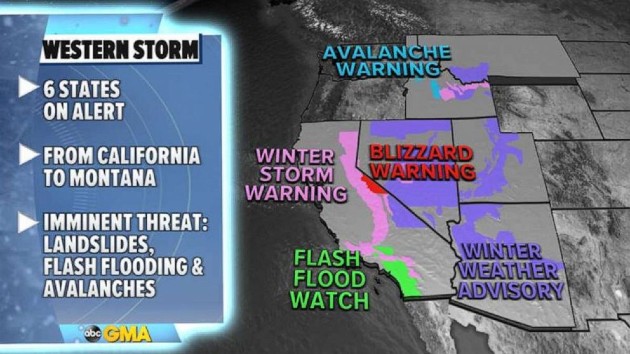
On Friday morning, six western states are on alert for flooding, snow and avalanches. The heaviest rain will be in Southern California, around San Diego, where flash flooding is possible.
Winter weather alerts have been issued for the Rockies, where some areas could see 6 to 12 inches of snow in the next 24 hours.
In the East, 13 states are on alert for cold and snow due to the storm.
A winter storm watch has already has been issued from Iowa to Ohio, including Chicago, for Saturday into Sunday.
By Monday and Tuesday, the storm may become a Nor’easter off the East Coast, bringing heavy snow for parts of the Mid-Atlantic and coastal Northeast.
It is too early to say how much snow will fall in the Northeast, as weather models are not agreeing as of Friday morning.
Though it’s too soon to be certain, Chicago could see 5 to 9 inches of heavy snow this weekend.
Meanwhile, the Northeast — which will be hit by the storm in the coming days — is currently dealing with the coldest air mass so far this year and possibly in the last two years.
Wind chills Friday morning are below zero degrees in some areas and will stay that way for the rest of the day and into Saturday.
A wind chill advisory has been issued from West Virginia to New Hampshire, where some residents could feel temperatures as low as 35 below zero.
Copyright © 2021, ABC Audio. All rights reserved.