
 ABC NewsBY: DANIEL MANZO, ABC NEWS
(NEW YORK) — Two weather stories continue to unfold across the U.S. this weekend, one being a winter storm moving into the Northeast and the other being a major push of polar air into the Midwest that will linger through the next week.
The trailing cold front from the storm in the east is bringing some severe weather to parts of Florida and a tornado watch has been issued for parts of the state until 7 a.m., including Tampa Bay which is hosting the Super Bowl on Sunday.
Heavy snow is moving through the mid-Atlantic this morning and will begin to push into the major northeast cities through the morning hours.
Snowfall rates could reach 2 inches per hour in the heaviest bands of snow during the day today.
The ultimate location of these heavy bands will determine which areas get the most snow and which areas will get only a little.
In those heavier bands, visibility could quickly deteriorate and the most intense snowfall is expected in the Northeast through afternoon with the storm leaving the region early evening hours.
The latest computer model guidance is identifying that some of the heaviest bands of snow will likely remain just offshore.
However, there still is a potential for a couple of scattered heavy bands to moving to the northeast region on Sunday.
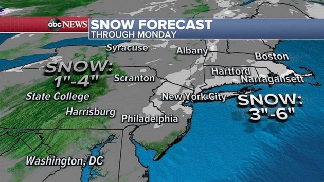
Due to some of these changes, anywhere from 1 to 6 inches of snow is possible in the Northeast on Sunday with the most being in southeast New England.
In and around the New York City area, 2 to 4 inches of snow is likely and, regardless of exact snow amounts, dangerous travel is expected.
Behind this storm, life threatening wind chills continues to dominate the Midwest with wind chills reaching as low as -50.
Wind chills this morning in major cities like Chicago and Indianapolis are well below zero and even parts of the South are getting some of their coldest air of the season with wind chills in the teens and single digits.
The main weather story through the upcoming week with be the brutally cold air that will persist over the central U.S.
The most notable point about this cold air is the duration of how long the cold air seems to be sticking around in the Midwest.
Several disturbances will ride the jet stream at the edge of this brutally cold air and bring some quick moving hits of snow across parts of the Midwest and Northeast this week.
Most of these systems appear to be quick moving though and only should only bring light snow to most regions.
Toward the end of the week, however, a couple of more organized systems could bring some widespread winter weather impacts, although it remains unclear how impactful the end of the week wintry weather will be at this point.
Unfortunately, the brutally cold air looks like it will expand its grip significantly by the end of the week and will dominate much of the eastern and central U.S. with even the east coast and southern regions seeing well below average temperatures.
Copyright © 2021, ABC Audio. All rights reserved.