
 ABC NewsBy MAX GOLEMBO, ABC News
(NEW YORK) — Nearly 40 states from Washington down to Texas and north to Maine are on alert Tuesday morning for winter weather with snow, ice and bitter cold, and about 70.4% of the entire country is currently covered by snow.
The first storm brought five reported tornadoes overnight to Florida, Georgia and North Carolina, where deaths and injuries were reported.
This same storm is now moving through the Northeast with ice and snow for inland areas and just mild rain for the I-95 corridor.
Additional snow and ice will be in northern New England on Tuesday where 6 to 10 inches of snow is possible through the afternoon.
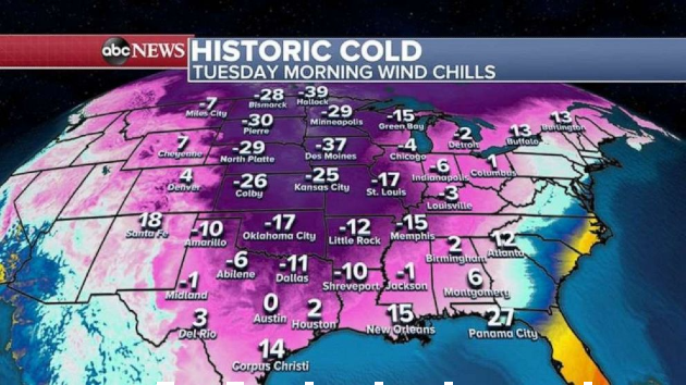
Behind this storm, a record breaking cold snap is occurring in the Central U.S. and this cold snap is being compared by the National Weather Service to cold blasts back in 1905 and the late 1800s.
Wind chills on Tuesday are below zero in Texas and parts of the Gulf Coast states.
By Thursday afternoon and evening, this new storm will move into the mid-Atlantic and the Northeast with ice, snow and heavy rain.
The I-95 corridor from Washington, D.C. to Philadelphia, New York City and Boston could see significant snow accumulation before snow changes to rain.
With this new storm, locally 3 to 6 inches of snow is possible for northern Texas, Oklahoma and Arkansas and 3 to 6 inches of snow will also be possible for the entire I-95 corridor.
Just to the west of major cities, 6 to 12 inches of snow could accumulate Thursday night.
Freezing rain and sleet is expected for Dallas, Texas, into Shreveport, Louisiana, and into North Carolina and Virginia, where there could be another ice storm.
Copyright © 2021, ABC Audio. All rights reserved.