
 ABC NewsBY: BRITTANY BORER, ABC NEWS
(NEW YORK) — Over 100 million Americans are under winter weather alerts this morning from Minnesota to Maine as the storm continues to track eastward.
Heavy snow is coming down this morning across the Great Lakes and Midwest and moderate to heavy rain is falling across the Ohio Valley into the Southeast.
Overnight in Chicago, there were reports of 1 inch of snow per hour snowfall rates and quarter-mile visibility.
By Sunday evening, snow will spread across the Midwest to the mid-Atlantic reaching Washington, D.C. and Philadelphia.
Snow spreads through New York City overnight and continues along the I-95 corridor throughout the day on Monday with the heaviest snow falling during the afternoon hours.
By Monday evening we could see a period of mixing and even a transition to a cold rain for coastal areas. Any freezing rain or sleet will make travel hazardous as hard surfaces will become icy.
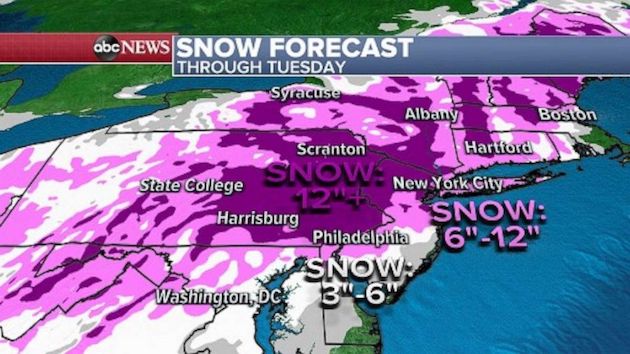
The heaviest snowfall totals of a foot or more will remain west of the coast and into higher elevations and New York and Philadelphia have a good chance of seeing 6 to 12 inches of snow with Washington, D.C. and Boston looking at totals in the 3 to 6 inch range.
Elsewhere, a series of systems will move across the Pacific Northwest and Northern California over the next few days bringing heavy rain.
There is a risk for flash flooding across southwest Oregon and Northern California where they could see as much as 5 inches of rain.
Additional snowfall of 1 to 2 feet is expected along the Cascade mountain range through Monday evening with an avalanche warning having been issued for the region from Lake Chelan southward to I-90 through 6 p.m. on Sunday.
Copyright © 2021, ABC Audio. All rights reserved.