
 ABC NewsBy MAX GOLEMBO, ABC News
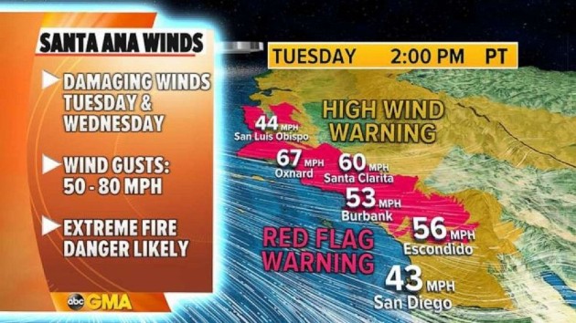
(NEW YORK) — The National Weather Service is warning that winds 50 to 80 mph are expected for California Tuesday with extreme fire danger.
The most dangerous winds and highest fire danger on Tuesday will be south of the San Francisco Bay area into Los Angeles.
A red flag warning has been issued for the area where dry offshore winds could create extreme fire conditions.
The Bay area will not miss out on the winds Tuesday and they could be gusty at 30 to 60 mph and locally 75 mph is possible.
Fire danger is not as extreme in the Bay area since the air is not as dry as it is in Southern California but, nevertheless, fire danger will be elevated for the region.
Elsewhere, in the East a wintry blast is moving through with wind chills below zero in the Midwest on Tuesday and heavy lake effect snow in the Northeast.
Already 8 to 13 inches of snow fell in West Virginia, western Pennsylvania and New York and several more inches are possible on Tuesday.
The snow in the last 24 hours caused accidents, spinouts and partial closures to I-90 between Buffalo, New York, and Erie, Pennsylvania.
Locally, the storm total could reach 18 inches in western New York and Pennsylvania later Tuesday.
That cold air is spilling into the northern U.S. Tuesday morning with wind chills below zero for some.
Some of that cold air will move into the Northeast Tuesday night and really spread across the area by the end of the week.
Copyright © 2021, ABC Audio. All rights reserved.