
 ABC NewsBy DANIEL MANZO and EMILY SHAPIRO, ABC News
(NEW YORK) — Another snowstorm is set to hit the Northeast this weekend as the Midwest braces for dangerous wind chills.
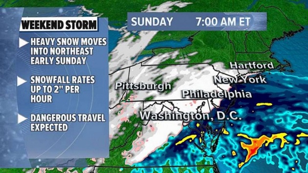
By dawn on Sunday, the snow is expected to begin from Washington, D.C., to Philadelphia and New York City.
During the day on Sunday, snow could be heavy at times across the Northeast, with snowfall rates up to 2 inches per hour. This will cause low visibility and dangerous road conditions.
The storm will be almost out of the Northeast by Sunday evening, with only some scattered snow showers remaining.
Here is one model representation of what we are expecting for tomorrow’s Nor’easter. There is still a fair amount of uncertainty in where the heaviest snow band(s) set up and thus the highest totals. Either way, we are expecting a snowy day Sunday. #NYwx #CTwx #NJwx pic.twitter.com/ZrtGsM0pTO
— NWS New York NY (@NWSNewYorkNY) February 6, 2021
Unlike Monday’s major snowstorm, this storm is a quick mover and snowfall amounts should be relatively lighter. However, forecast models are indicating that as the storm intensifies offshore, a band of very heavy snow will develop near the major Northeast cities on Sunday during the day.
About 4 to 7 inches of snow are expected to fall across much of the Northeast, and over 6 from eastern Pennsylvania to Massachusetts. There is a chance that a couple of isolated spots could get hit by torrential snow, which would push totals higher.
Meanwhile, a blast of polar air is moving into the Midwest.
On Saturday morning wind chills were expected to be as low as -40 degrees in parts of Minnesota and North Dakota. On Sunday wind chills could be even lower, as -50 degree wind chills are possible in parts of the upper Midwest. It will feel like -30 or lower in Chicago and Green Bay.
This cold air is sticking around with no real end in sight for the Central U.S.
Next week the Arctic air will likely reach the Southern Plains with below zero wind chills for Texas. And as the cold air continues across the country, there is a possibility that another storm will form in a week.
Copyright © 2021, ABC Audio. All rights reserved.