
 ABC NewsBy MAX GOLEMBO, ABC News
(NEW YORK) — A dangerous storm is moving out of the Midwest on Thursday morning and into the Northeast later in the day and into the evening.
The storm has already brought winds up to 74 mph to the Plains and parts of Midwest with up to 9 inches of snow and blizzard conditions.
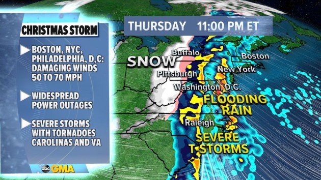
The storm system is now moving east with damaging winds to hit the cities along the I-95 corridor from Washington, D.C., to Boston, Massachusetts.
On Christmas morning, torrential rain will be falling from New York City to Boston with damaging winds — millions could be without power and winds could gust as high as 60 to 70 mph from the New Jersey coastline to New York City and into Boston.
In addition to damaging winds, heavy rain could cause flash flooding for the I-95 corridor — flood watches have been issued for the Northeast, where 2 to 4 inches of rain could fall in a matter of hours.
There is also a threat for tornadoes in the Carolinas Thursday.
Behind the incoming storm system, wind chills are dangerously low, with some readings approaching -40 degrees, which could lead to frost bite in just minutes.
Temperatures will be crashing Friday evening on the East Coast from Maine to Florida. By Saturday morning, wind chills will be in the 20s and 30s, including in central and southern Florida.
Copyright © 2020, ABC Audio. All rights reserved.